The Mountain range that runs down the middle of Costa Rica allows the 2 different oceans on opposite sides of the country to control the 2 distinct weather patterns on each geographical side of the country.
The Pacific side of the country has distinct dry and wet seasons, with the dry season between December - May.
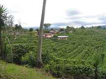
Northern Pacific Region
In the Northern Pacific Region, 'Dry Tropical Forests' are predominate, while in the Southern Pacific region, 'Humid Tropical Forests' are predominate. The Central Valley, where San Jose is located, also enjoys about 6 months of dry season (December to May). The wet or rainy season on the Pacific does not mean rain all day long but rather mid-afternoon rain showers like clock work almost every day from the middle of May to late November much like the summer weather in the south of the U.S. September to mid-November is the wettest time of the year on the Pacific side of the country, with October traditionally the wettest month. The average temperature on the coast is 27°C (81°F) and 17°C (63°F) up in the mountains. Average day time temperatures along the coast are at their highest between January and May, reaching 32°C (90°F), and generally, temperatures never drop below 22°C (71°F) at night. Meanwhile, up in the mountains, the temperature can drop to 9°C (48°F). The relative humidity here is relatively constant at 85%. During January and February, it drops to between 75 and 80%, and reaches its peak of 90% (+/-) in June, September and November. At least the hottest months do not coincide with the highest humidity levels. Winds from the south dominate the days, while the nights are usually calm with slight breezes from the east.
Central Pacific Region
The Central Pacific Region includes the western parts of the San Jose and Puntarenas Provinces, extending south from the Tarcoles River to the Mouth of the Baru River (which is just north of Dominical). This zone includes Jaco, Quepos, Manuel Antonio and Parrita.
This area has less continuity in climate than the other climatic regions because it includes coastal and high mountainous regions (0 to 1880m, 0 to 6167 ft. above sea level). The dry season is from January to March, with February being the driest month. The rest of the year is technically the rainy season, October being the rainiest. But, despite the long “rainy period”, there are (on average) five hours of sun during the rainy months. The days begin sunny and pleasurable, with rains moving in the afternoon or night. The average temperature on the coast is 27°C (81°F) and 17°C (63°F) up in the mountains. Average day time temperatures along the coast are at their highest between January and May, reaching 32°C (90°F), and generally, temperatures never drop below 22°C (71°F) at night. The relative humidity here is relatively constant at 85%. During January and February, it drops to between 75 and 80%, and reaches its peak of 90% (+/-) in June, September and November.
South Pacific Region
The South Pacific has a shorter dry season and experiences more intense afternoon storms than its northern counterpart, the North Pacific. From the end of December until April, the dry season is marked with 75% humidity, and average temperatures of 26°C (79°F) along the coast (average daytime temps of 31°C (88°F) and night time temperatures of 22°C (71°F). In the lowlands during the rainy season, May through November, 4000mm (157 in.) of rain falls annually and on the Osa Peninsula, more than 5000mm (197 in. - that’s 16.4 feet ) of rain falls annually. This region maintains an average humidity of 75% during the dry season, escalating slightly during the rainy season, reaching 90% in July, October and December. Strangely enough, late June or July typically experiences a "veranillo" (little dry season) with a dramatic decrease in rain but is one of the most humid months.
The Caribbean or Atlantic side of the country has no real prolonged dry or wet seasons. The least rainy months tend to be February/March/April and September/October. "Normal" in the Caribbean is clear mornings with late afternoon or evening downpours. Similar to summer weather in the south of the U.S. or in Hawaiian Island of Kauai or Hawaii. Even in the rainiest months there are usually some hours of sun to be found. Temperatures are relatively constant all year ranging from 25 to 27°C (77 to 81°F) on average. May, June and October are the warmest months with average daily highs of 31°C (88°F) and the coolest day time temperatures are found during January, February, July and December, with an average of 29°C (84°F). Days are blessed with trade winds that help buffer the humidity. Night-time temperatures range from 20 to 22°C (68- 71°F) and are usually cool and comfortable.
Humidity values are fairly constant throughout the year. January through April tend to be least humid months at 80%, while the rest of the year experiences averages around 85%. June, July, November and December are the most humid with values reaching 90% (these are also the rainiest months).
Northern Zone Region
Northern Zone Region includes all cities north of the central valley to the Nicaraguan border and Lake Nicaragua including Monteverde, La Fortuna (Arenal), San Carlos, and the northern part of the Alajuela and Heredia Provinces. Altitude affects the quantity of rain received, but the rain patterns are the same between the lowlands and the mountains. January through April are the driest months in both locations. Decreased humidity levels coincide with decreased rain and are at their lowest from March until April with an average of 75 %. The rest of the year, relative humidity levels average 85% in both the lowlands and mountains. Temperatures are definitely affected by altitude. In the lowlands, temperatures hover around 30°C (86°F) (daytime) whereas in the mountainous regions, daytime temperatures average 21°C (70°F). Nights get quite cool in the mountains dropping to as low as 13°C (55 °F) at night, but only to 20°C (68 °F) in the lowlands. Winds are usually from the south averaging 5.5km/h (3.4mph) throughout the year, but as you go up in elevation, wind speeds increase. Monteverde can be very windy during the dry season.
Central Valley Region
The Central Valley Region includes parts of the provinces of Heredia, San Jose, Alajuela and Cartago, including popular cites like San Jose, Heredia, Escazu, Santa Ana, Cartago, Barva and Grecia (among many others). The average annual temperatures are between 22°C (72°F) and 24°C (75°F), and these do not vary much throughout the year. The max usually averages 29°C (84°F) and the lowest averages 18°C (64°). Relative humidity averages about 75%, dropping to 69% during the dry season. The dry season is December to March, with April and November being months of transition. July tends to be the driest of the wet months and is referred to as “veranillo” (little dry season). This said, we can summarize and say that the dry season generally extends from December until April. During this time the humidity is lower. This time of year (Jan- March, more specifically) is also marked with persistent NE winds (as high as 30 km/h) and lots of sun (eight hours or more per day). The rainy season (May through November) is characterized by less sun and lots more rain. Usually, you get at least four hours of sun in the morning (6 a.m. until 10 a.m., or later) before the afternoon storms develop. September and October are typically the rainiest months (averaging 650mm (26 in.) per month) of the year and the most humid. The humidity never really goes above 80%.